
California has been ravaged by back-to-back atmospheric rivers in recent weeks, dropping record amounts of rain and leaving dozens of roads unusable. More rain is expected.
Will Arnold, the spokesperson for the state’s transportation department, stated that at least 40 state roads were closed in all of California as of Wednesday night.
Arnold stated, “We are asking the public, please stay at home and avoid non-essential trips.
According to the National Weather Service, Californians received between 50% and 70% of the annual precipitation in 16 days. Particularly in the mountains around Santa Barbara, isolated areas have received more than 90% of their annual precipitation.
In the last two weeks, at least 18 people died from the storms. The deluge caused flooding and trees to fall in many areas. After Kyle Doan, 5 years old, was swept away by floodwaters Monday morning, more National Guard personnel were present in San Luis Obispo County to search for him.
Storm systems caused flooding, sinkholes, and crumbled roads, as well as the destruction of homes and sewage that forced thousands to flee their homes.
Evacuations are ongoing. An evacuation alert was issued Wednesday in Solano County in the Bay Area for 1,600 residents amid fears that Lake Curry might flood downstream.
California Lt. Governor Eleni Kounalakis stated that “we’ve had six hurricanes in the past two weeks.” Wednesday’s statement was made by Eleni Kounalakis. “This is the type of weather that you would get in one year, and we compressed it down to two weeks.”
Although much of the state is receiving some relief from the rain on Thursday, the barrage continues.
In the next 10 days, California will be hit by three more atmospheric river events. These are long, narrow regions of the atmosphere that can transport water thousands of miles.
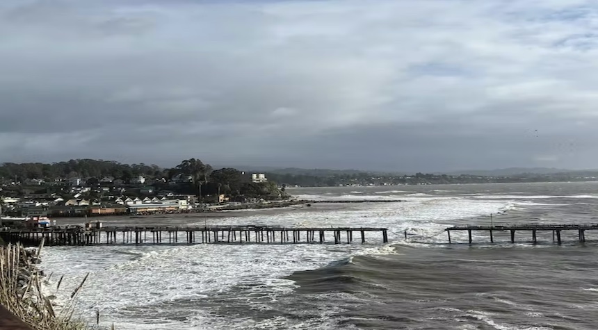
California Governor Gavin Newsom stated that “This is quite literally the calm between — and before — the storms.” Gavin Newsom, standing next to a pier that was destroyed by a recent storm, said this in a Facebook Video.
Over the next few days, several more rounds of rain will be expected to affect the state. On Friday, more substantial rains will be seen in central California and then spread to the south throughout most of the state on Saturday.
The rainfall totals in California have been staggering since December 26th, when an unrelenting parade of atmospheric rivers began to pummel the state.
According to the National Weather Service, downtown San Francisco saw 13.59 inches of rain between December 26-January 10, while Napa received 11.21 inches, and Sacramento got 9.58 inches.
Oakland saw 12.90 inches of rain in that 16-day period. This is the most precipitous period in Oakland’s history, and it accounts for 69% of its annual average.
According to the Storm Prediction Center, California’s atmospheric rivers will continue their impact into next week. Here are some things to look forward to:
Thursday: Rain will be limited along the coast of northern California and into Oregon, and Washington through Thursday night. There is a slight chance that excessive rain may occur in northwestern California.
Friday: Friday’s atmospheric river shifts east and will pummel the central California coast and northern California coastline. Winter storm watches will be in effect throughout the Sierra Nevada Mountain range.
Saturday: Saturday will see a second system moving in. The rain will spread southward and impact the entire state. For central California, excessive rainfall warnings are likely. High snowfall may cause dangerous mountain travel conditions Friday through Saturday at elevations above 5,000 feet, and along the northern and central California passes.
Sunday: The moisture will shift to the inland west states, bringing drought relief to Four Corners. The West Coast will see more snow and rainfall.
Monday: A second round of rain will hit southern California, bringing more moisture to the Four Corners. This will continue into Tuesday. Northern California will experience a brief respite.
Tuesday: The Pacific Northwest and northern California will be hit by a new round of moisture, which will last into Wednesday. A break could be possible for southern California and central California.
Although none of these storms will have the same impact as the last ones, they could still be significant when combined. This is because the soil is too saturated to absorb more rain and the streets are still flooded from previous storms.
According to the storm prediction center, “Limited flooding effects are expected across Northern California and Central California during next week due to saturated conditions.”